2016 Miramichi Tag Returns
The Department of Fisheries and Oceans uses trap nets set in the Miramichi estuary to estimate the run of salmon and grilse running into the river each year. Each day from June through October DFO employees go out to the net strung on poles driven into the river bottom and count the fish trapped in the net. These fish are alive and unharmed. The fish are counted, weighed, measured, a small metal tag with a number is fixed to their back with a thin wire, and they are released back into the river. Anglers sometimes catch these tagged fish, and we can learn a lot about how the fish move in the river from information connected to these tags.
DFO tag from Millerton in Cock Salmon 10/13/16
This year we caught bright salmon in every month from early June on, yet the only tagged fish we got were caught on 9/28, 10/10 and 10/13. I have no idea why it happened that way. The history of each of these tagged fish is always very interesting:
- On 9/28 we caught a hen salmon at Campbell’s Pool with tag #41999. I should say that we believe that is what the number was. It was getting dark and the flash on my camera reflected off the tag. Darrell Warren and I tried to remember the number, but we had 44199. There is no such number among tags used, but this one given to us by DFO matches perfectly so I’ve accepted it.
The information on that tag is that the fish was tagged at 82.2CM or about 33 inches on 9/16/2016.The water was low this fall, and at least this fish took its time in the lower river. Campbell’s is about 14 miles above the head of tide, and where the fish was tagged at Millerton is about 8 miles downriver from that point. That makes the journey from the Millerton trap to Campbell’s Pool about 22 miles. Some other fish that we’ve recovered before showed up just a couple of days after being tagged. This fish, though, took 12. I remember that evening’s fishing. We had a fair number of fish showing in the lower part of the pool, but they were not good takers. A friend and I only caught one other fish that evening, an untagged grilse. - The next tagged fish was not taken until 10/10. That fish was a male grilse – my notes say that I also lost a much larger fish that same evening. This fish was tag #45067, and it had originally been tagged by the DFO at Millerton on 10/6 just 4 days before. The grilse was 54.6 cm or about 22 inches long. Doubtless it could have arrived even a couple of days earlier, but 4 is still a fairly short trip.
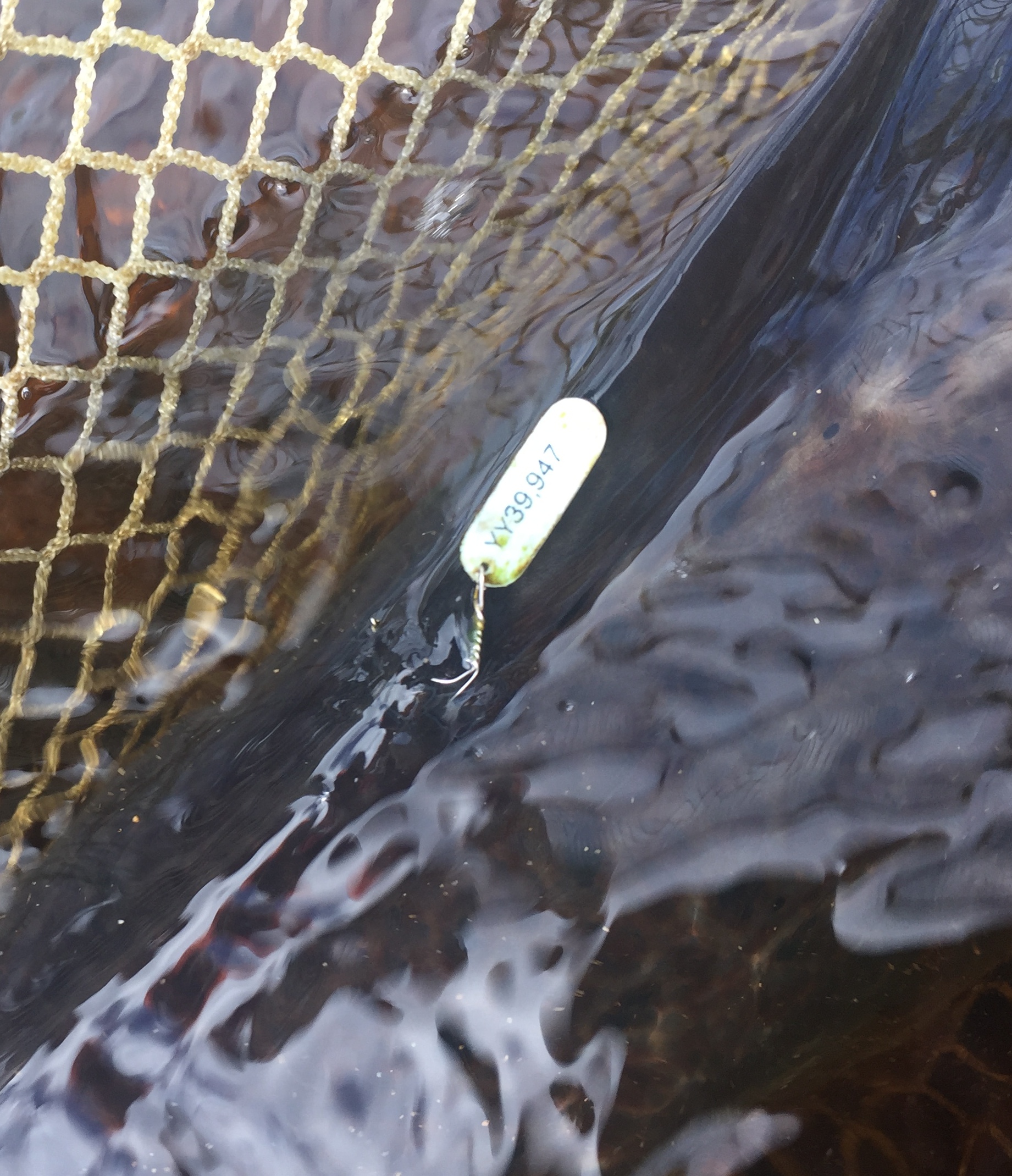
- The third and final tagged fish was the next to last fish of the season. I got this fish at Mahoney Brook in the home pool in front of camp, at quite a low water level on 10/13. The Mahoney Brook camp is 22 miles up the Cains River, and so is about 44 miles from the trap. This was tag #39947, and it is the lovely cock salmon that is in the video on my website! This salmon put up an outrageous fight zipping up and down the narrow home pool, skipping along the surface on its side and violently changing directions. It was really quite something to see. At Millerton the fish measured 81.4CM or about 32 inches long. This would make the salmon about 12 pounds, though we had estimated it closer to 15, oh well… The hook pulled out in the net, and as you saw in the video, after a brief recovery it swam strongly off. I hope it had the pleasure of sidling up to the biggest hen in the river…it deserved it.
An interesting thing about this cockfish was that it had originally been tagged at Millerton on July 4th! We have caught sea-liced fish at Mahoney Brook that could not have been in fresh water much over 2 days – because they were still carrying sea lice – so there is nothing holding the fish back if they are in a hurry. The upper Cains River can become very tiny in a warm, dry summer. Perhaps there is some natural selection message in the late running fish of the Cains. Maybe fish that ran up the Cains early often died before spawning, and the river naturally developed a fall run, or maybe through some instincts that we don’t understand the fish just know better than to ascend the river too early. You have to wonder, though, why fish come in to the river during July if they aren’t going to go up the river for three and a half months? So where in the river did that salmon spend its time between July 4 and October 13th? Who knows is of course the only certain answer, but I would bet that it went into the Cains as a lot of fish did this past summer during the middle of July. There are a number of good holding pools in the lower Cains strung out from the mouth just above Black Brook up to the Mouth of Sabbies River. That fish could have been laying in any of these, and then inched its way up the Cains with every little bit of rain that reached the river during September.
Looking for something to give a fellow salmon fisher for Christmas?
Here is a special offer from me. Until Christmas If you purchase two copies of my book Closing the Season I will ship a third one at no additional charge. Also, for every additional one that you purchase I will match it with another free copy. When you click to “proceed to checkout” there is a place on the website for notes on your order. Just write in there the name and address of who to send each of the books to. You can also e-mail me at bigbass@maine.rr.com if this needs a little more explanation or you have a question. But wait, as they say in those sleazy infomercials, that’s not all… I will also include with each book – even if you order just one – an “8 x 10” copy of Percy Nobbs 1949 map of the Miramichi drainage. Even though the map is black and white I will run the copies in full color process on a quality stock that gives the map a lovely antique look.
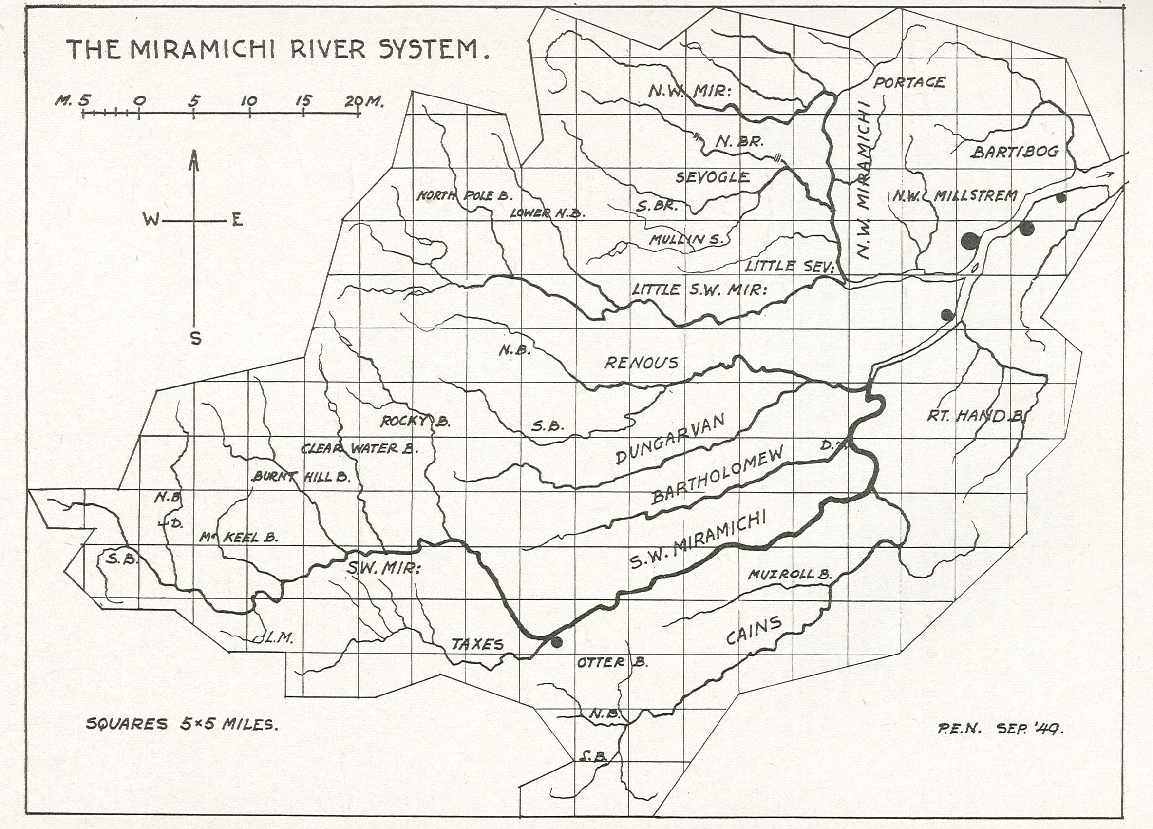
Percy Nobbs 1949 Map of Miramichi River System